Waterfalls in the Green Mountain Forest and Mad River Valley
I’m at Green Mountain Family Campground this weekend (review coming). It’s the first of 5 new to me campgrounds I have booked in 2021. One of the things that attracted me to this place is that on their website they describe a waterfall loop. You can see it here. So that was my plan for day 1.
Today I woke up to an absolutely beautiful morning at the campground around 6am and quickly began my pregame. My pregame was predicated on my annual doctor’s visit Thursday morning and the resulting labs that arrived in my inbox last night. Normal. So…I dipped into the private stock/special reserve for…….not one, not two, but three Half-Caf cups of coffee. That is a celebration indeed.
I enjoyed a shower in the Bullet, much more so than in the Gulf Stream last year. I can stand up fine in it and don’t have to squat like a monkey (do monkey’s squat? I bet they do) when I wash my hair.
Now that I was clean and 3x half caffeinated I took snapshots of the directions from the link above (I mean…Ripton and Hancock are not renowned for their connections to major internet backbones), took the requisite left on 116 and drove 3 miles south. Success! There was the sign for Abbey Pond Trail, and in I pulled. Twice. Because the first time I pulled into some old logging trail. Whomever logged it didn’t drive a F-150, or at least turn it around where I did. Then I pulled into the proper road…marked by an arrow mocking my first decision.
An uneventful mile later, with GPS still working, I came to the trail head. One other car. Perfect. I parked and started up the trail. Since GPS was working I fired up the googles to see what the hike was going to be like. I couldn’t hear anything. And the googles did not disappoint. They advised me 3/10’s of a mile and as I pocketed my phone the roar of water began to reach me.
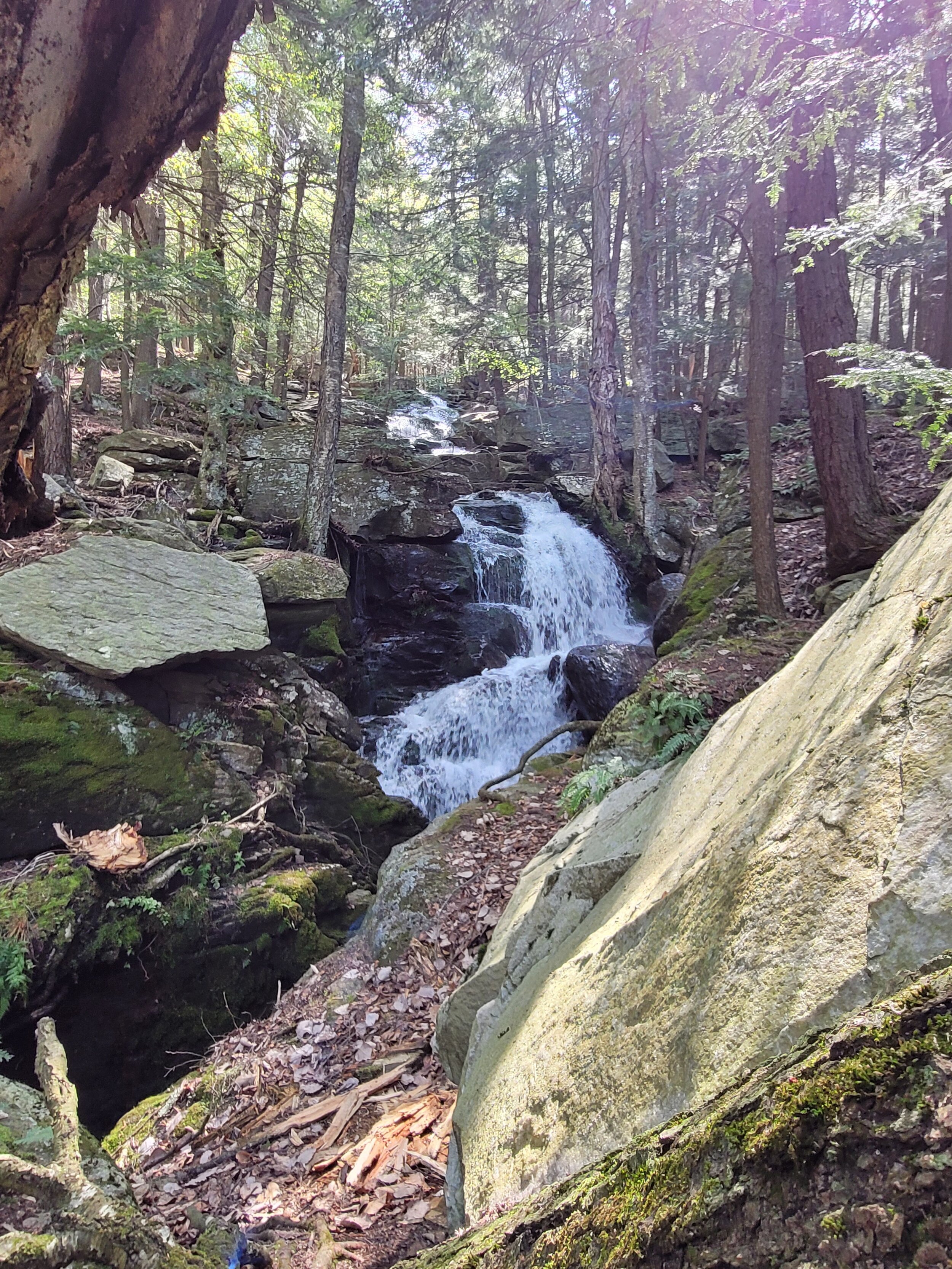
Abbey Pond Cascades
The trail led to a well built wooden bridge over a series of cascading falls. The origin is Abbey Pond, a 1.8 mile hike up the hill. But come on…it’s not like I woke up all wild and crazy in Vegas and had fully caffeinated coffee.
That would have to wait. Here are a few other pics from this pretty spot.


With one falls down, and quite happy with the first one, I made my way back to 116, and noted it would be 14 miles to Bailey Falls. Into Middlebury I went and foolishly let a dump truck get in front of me as I turned onto 125. What a beautiful ride though. Mountain streams, rivers, the Green Mountain Forest…I would have been ok with 114 miles. Somewhere between Ripton and Breadloaf the GPS became a dash ornament, but I was prepared. As I passed the Middlebury Snow Bowl and began the ascent I realized this next waterfall could be a huge one. Cresting the gap and a sharp descent later I had to brake pretty hard at the mile 14 mark for a pull off that appeared to be unmarked. With no googles to guide me I was left to my own devices…or without my devices. Like a reality show where you have to pretend you were living in 1990. There was a large sign that said I should not be parked where I was from November to May. Today is May 15th. That could be part of November to May. I found the sign to be ambiguous.
The chain link across the hidden access road was less ambiguous, but low enough to step over. I doubt that sign or chain was there in 1990. And this is what I’ve been reduced to soo….onward. I came to another similarly well built bridge over a mountain stream, and behind it….ummm…. a ski lift.

Bailey Falls (not)
I guess this is the backside of the Snow Bowl. I could hear no falls. The stream I crossed was very calm. And I was growing uncomfortable with my well planned defense of “November to May is ambiguous”. I’d say that I’m having regrets about turning back, but that is not the case. Upon returning to the campground and 2021 I found this about Bailey Falls:
“From the parking pull-off on VT 125, walk 150 feet downhill on the dirt road. Turn left and cross a wooden bridge over a stream. After crossing the bridge, you'll soon see one of the Middlebury Snow Bowl ski lifts in front of you. If you look left, you'll see the bottom of a ski trail on a moderately steep hill. Turn left and start walking up that ski hill. About 2/3rds of the way up that hill, turn left and enter the woods on a very rough and not-always-obvious path. You are about 0.15 mile from the trailhead at this point. Follow the path or bushwhack about 150 feet over to the brook. You'll descend about 20 feet before you reach the base of the lowermost falls. There are additional falls upstream, including a 10-foot falls, but you'll need to bushwhack along the edge of the brook and ravine to reach them. Exploring up and down the brook, which photographers will likely want to do, requires some sure footing and a few tricky maneuvers.
I’m a camper, not an acrobat. Anyway, back to the truck I went to continue my journey. Next up was Texas Falls. 3 miles away in Hancock and hopefully will improve my 50% waterfall find rate. A couple of minutes later signs for Texas Falls were clearly visible and it was a well marked turn off of 125 that led to a paved road along a river that widened to a large parking area about a mile in. Texas Falls is really pretty. They have lots of hiking trails and a number of different places to view the falls from. I spent some time at this one. Lots of easy trails for walking around, the day was beautiful, my success rate had gone up and the spot is simply amazing. Here are some pictures of it, definitely well worth a visit for a picnic in my opinion.


Three down, three to go. Back out on 125 I go and head down the hill into Hancock. I pass my second general store of the day (Ripton had one as well) and remember that I’m a big fan of general stores in Vermont. Any 5 aisle store where you can buy feed for your horse, bud light for your fridge and bullets to stock your freezer with good aim is worth visiting. With space being a commodity, a product making it onto a shelf in a country store tells you about the community. I like Hancock. Plus, I passed the Hancock Hotel. While I’ve never stayed there, I’ve heard that they have good food there.

Ok, I bang a right on 100 and note the mileage since Texas Falls and begin to look for Moss Glen Falls as I’m headed thru the very picturesque Mad River Valley. I start seeing people swimming in swimming holes, and I do have a bathing suit on…but I’m on a waterfall mission. Any ordinary swimming hole simply won’t do. Undeterred by the fact that the first three were not swimmable (and one not even found) I’m glued to my odometer in search of Moss Glen Falls. I am not disappointed. As 100 North takes a sharp turn to the right there is a pull off on the left with signs. I manage to not be what I can only assume is a daily wreck as someone pulls into the parking lot. Moss Glen is located in Granville and is a very steep and narrow falls literally running off a cliff on the side of the road. It’s very fun to look at, just very difficult to get a picture of that seems to do it justice. But I tried and here they are:


With stop number 4 having been enjoyable and a success, I’m back on 100 North, headed for the town of Warren. It is there that I expect to find Warren Falls, which makes a lot more sense than finding Texas Falls in Hancock. Confidence is high. 7 miles later I come upon the Warren Falls Hotel (not clear if they have good food or not, they need a new marketing company it seems) and about 1/4 mile later a somewhat less treacherous pull off across 50 mph traffic finds me at Warren Falls. Ample parking, good signage and super cool. A trail leads down to the river which isn’t really exciting, but there were plenty of bird watchers doing bird watcher things. I saw lot of birds, but left my book at home, so the only one I can say I positively identified was a crow. And I’m about 75% sure on the chickadees. I followed the path toward the cascades and when I came upon them was really impressed. Once again it was really hard to get a good shot of these falls, but the white water plunges off water smoothed rocks into a beautiful tranquil emerald pool. It makes you want to jump in. You shouldn’t. This would be another great spot for a picnic. Here are the pics I came away with.


With waterfall 5 being a grand success I look at the route to waterfall 6 and then my camper. I decide to take the Lincoln Gap road. Heights never bothered me when I was younger. Heights bother me now. And I elect to take this route nonetheless. I throw the truck in 4 wheel drive. I’m not sure why. I guess in hopes that I would take some solace in the fact that I actually have 4 wheel drive as I tumble off a 3000 foot cliff. I’m placated by small victories. I was doing well until what appeared to be a 40 year old 4 cylinder Ford Escort riding my ass as I was trying to stay between the cliff I just mentioned and the irresponsible Lincoln Gap natives going 80 in the other direction on a road built for the width of just two Escorts. The logging road was much more enjoyable. But I digress.
Bristol Falls…..or Bartlett Falls. There seems to be some controversy on what they are named, or if there are in fact two separate sets of falls. I may never know. I stopped at Eagle Park. Appropriate. I wonder what came first. Mount Abe Eagles, or Eagle Park? Anyway, that was the wrong stop. The googles were working again and told me I was one mile short of my destination so I went back out on the now thankfully flat Lincoln Gap Road and eased into what I will call Bristol Falls. Not a lot here. Pretty, but you can’t get a really good angle to see much. Unless you’re in the falls. I did not want to be in them. I think maybe from the other bank of the river you could, but it appeared to be private property and I’d already trespassed the Middlebury Snow Bowl today. My hypocrisy only goes so far. So I snapped a few photos, and am sharing them with you.


So the day was a resounding success. It’s 54 miles and about 90 minutes of driving time. It took me about 3.5 hours with what I considered unrushed and the right amount of time at each location. Highly recommend this trip to anybody, local or not, it’s full of beautiful spots and sure to be enjoyed by all. Maybe don’t take the Lincoln Gap Road!